A critical component of Data Spaces – those supporting the European Green Deal strategy or beyond – will be their management of dynamic data series coming from many different sources, such as various sensors. To enable interoperable communication between such data series, as well as ease their interpretation and (re-)use, the Open Geospatial Consortium (OGC) long ago developed the SensorThings API Standard. In this post, the Standard is introduced together with the planned developments and initial results from two Horizon Europe projects on Green Deal Data Spaces in which OGC is involved: ‘All Data for Green Deal’ (AD4GD) and ‘Urban Data Space for Green Deal’ (USAGE).
The European Green Deal and digital data strategies
The European Green Deal aims to transition Europe to a sustainable and resource-efficient economy and governance while improving the well-being of citizens. Several objectives shall contribute to the main goal, including: transforming the economy and societies; making transport sustainable for all; innovating industry; cleaning energy systems; renovating buildings for greener lifestyles; working with nature to preserve the planet; and boosting global climate actions. European Green Deal objectives are, in turn, in line with the United Nations Sustainable Development Goals.
Data, especially dynamic data from sensors, plays an essential role in monitoring, analysing, and understanding the status and evolution of the aforementioned sectors, the influence of proposed policies and decisions, and when simulating and measuring the effectiveness of newly applied measures, models, or changed conditions.
Further, using open protocols and data management practices aligned with the FAIR data principles of Findability, Accessibility, Interoperability, and Reusability, increases efficiency and better supports democracy through data transparency and accessibility.
Digitalisation is recognised as a powerful support to the European Green Deal and Sustainable Development Goals – on the condition that a strategy is followed that ensures efficient and optimised use and management of digital data and associated tools. The European Strategy for Data and the European Data Spaces policies are intended to rule, define, and support such digitalisation towards fair, aware, and efficient data sharing and use.
OGC SensorThings API: an Open model for sensor data
The OGC SensorThings API was developed by the OGC SensorThings Standard Working Group as an open Standard that enables the web-based management, storage, sharing, and analysis of Internet of Things (IoT)-based sensor observation data.
The OGC SensorThings API consists of a data model and an API split across two documents: (1) the Sensing part and (2) the Tasking part (which is currently in the planning phase). The Sensing part allows IoT devices and applications to create, read, update, and delete IoT data and metadata in a SensorThings service.
The SensorThings entities data model is based on the OGC/ISO Observation and Measurement (O&M) model [OGC 10-004r3 and ISO 19156:2011]. The model can be understood as follows: an “observation” is modelled as a datastream connected to a “sensor” and a “thing” that produces a “result” (aka “ObservedProperty”) whose value is an estimate of a property of the “observation target” (aka “FeatureOfInterest”).
For example: when measuring the temperature in a room, the “Observation” is each measurement or data value at a certain moment in time; the “sensor” is the thermometer; the “thing” is the device that reads and transmits the measurement from the thermometer; and the “result” (ObservedProperty) is the temperature measured by the sensor. The ObservedProperty is associated with the “observation target” (FeatureOfInterest), in this case, the part of the room that the sensor resides in.
An Observation instance is classified by its event time, FeatureOfInterest, ObservedProperty, and the procedure used (often a Sensor). Moreover, “Things” are also modelled in the SensorThings API, and its definition follows the ITU-T definition: “an object of the physical world (physical things) or the information world (virtual things) that is capable of being identified and integrated into communication networks” [ITU-T Y.2060]. The geographical locations of Things are useful in almost every application (in particular in remote sensing, where the object measured is far apart from the actual device) and, as a result, are included as well.
SensorThings API for Green Deal Data Spaces: the USAGE and AD4GD projects
Recent examples of adoption of the SensorThings API standard include two Horizon Europe projects – in which OGC participates as a consortium partner – that intend to provide solutions for the Green Deal Data Space: ‘Urban Data Space for Green Deal’ (USAGE), and All Data for Green Deal (AD4GD).
By using standards for data/service interoperability and integration, USAGE will provide solutions that make city-level environmental & climate data Findable, Accessible, Interoperable, and Reusable (FAIR). This means innovating governance mechanisms, consolidated arrangements, AI-based tools, and data analytics to better share, access, and use the city-level data generated from Earth Observation, Internet of Things, authoritative- and crowd-sources.
USAGE use cases will range from air pollution mobility to mitigation strategies for climate change (such as minimising the impact of urban heat islands and increased floods) as well as smart traffic management. USAGE pilots and use-cases include the cities of Ferrara (Italy), Zaragoza (Spain), Graz (Austria), and Leuven (Belgium). In Ferrara, citizen science initiatives with high schools and volunteers are already scheduled to support USAGE use cases and biodiversity.
AD4GD aims to co-create a Green Deal Data Space with stakeholders and end-users. One of the main objectives of the project is the integration of Citizen Science data together with in-situ observations, results from artificial intelligence models, and remote sensing data. AD4GD will leverage standards and semantic technologies to reach this objective.
AD4GD pilots and use cases include water quality in Berlin’s lakes (Germany), biodiversity in the Metropolitan Area of Barcelona (Spain), and air quality with low-cost sensors in Northern Italy.
The implementation of SensorThings API is a critical part of both projects. Sensors provide essential data for several treated use cases, including for air quality, water quality, traffic status, animal species tracking, weather & environmental parameters, and more.
By using an open and shared protocol to communicate data, such as the SensorThings API Standard, the data required for the projects can come from different types of sensors from different vendors, and the sensors can be managed by the government, private industry, or single citizens. Additionally, SensorThings API’s capacity to link observations to definitions of variables and units of measurement facilitates the automatic aggregation and integration of data while increasing its semantic interoperability.
The two projects plan to further develop the SensorThings API Standard by using it in the provided solutions and recommended architecture while experimenting with its integration with other sensors and data within the developed software. In USAGE specifically, the SensorThings API plugin for QGIS will be refactored to embed access to SensorThings API endpoints in the core part of QGIS and extend it to support data analytics.
Also further implemented and tested in AD4GD and USAGE is SensorThings API Plus. To more effectively manage data produced by multiple actors with different licenses (such as in citizen science data), SensorThings API Plus extends the OGC SensorThings API Part 1: Sensing Version 1.1 (STA) Standard data model and improves the security aspects of the standard. Its development was started in the COS4CLOUD project and was further developed in citiobs.
Promoting the SensorThings API with stakeholders
Both AG4GD and USAGE additionally recognise that a fundamental challenge facing the uptake of effective solutions is firstly alerting the stakeholders and end users of its existence, and then training them in its use. Therefore, within the USAGE project, some workshops were organised by OGC and project partner DedaNext.

The first workshop was organised on February 1, 2023, in Ferrara (and online). The workshop opened with an introduction to the SensorThings API Standard along with several examples of Open Source implementations. Marco Minghini, from the Joint Research Centre group working on the INSPIRE Directive framework and implementation, presented the INSPIRE Good Practice recommendation of OGC SensorThings API. The API4INSPIRE project was also presented, which assessed the implications of using APIs to exchange data, including the SensorThings API. A recording of this initial part of the workshop is available on the OGC YouTube Channel.
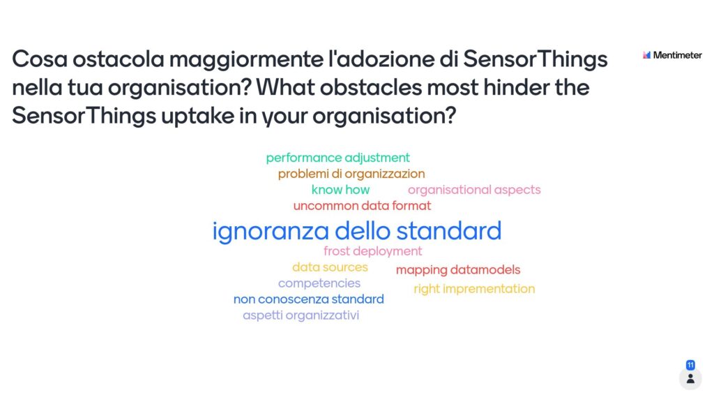
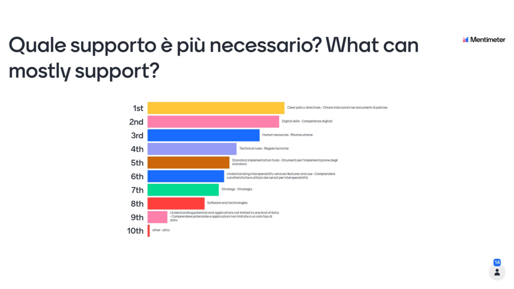
Next up was a round table where stakeholders from national and regional Italian bodies discussed current solutions for sharing dynamic data as well as challenges facing the adoption of SensorThings API for improving data management quality and FAIRness. The audience was prompted to answer two questions through interactive questionnaire tools: 1) What obstacles most hinder the SensorThings API uptake in your organisation? And 2) What could better support the adoption of the Standard?
To facilitate the participation of a wider audience, the questions and related answers were allowed in both Italian and English. The lack of knowledge about the standard was recognised as a primary reason blocking its adoption, as seen in Figure 1. For this reason, the recording of the first informative part of the workshop was published online and advertised as part of the Location Innovation Academy and beyond. Additionally, a second SensorThings API webinar was held on April 20, 2023, organised by the Italian Agency for Digitalisation (AgID), and held in Italian.

The second question pointed out that the biggest driver for uptake of the SensorThings API Standard would be in the form of clear policy directives. The following ranked factors – digital skills and human resources, respectively – confirm once again the need for training and new professional skills. This problem is the impetus behind the launch of the Location Innovation Academy, developed in the European GeoE3 project and hosted by OGC.
The interest around the SensorThings API Standard continues to grow, with more developments, applications, and implementations expected in the future.
OGC Members interested in staying up to date on the progress of the SensorThings API Standard, or contributing to its development, are encouraged to join the Connected Systems / SensorThings Standads Working Group via the OGC Portal. Non-OGC members who would like to know more about participating in the SWG are encouraged to contact the OGC Standards Program.

The USAGE project has received funding from the European Union’s Horizon Europe Framework Programme for Research and Innovation under the Grant Agreement no 101059950.
The AD4GD project has received funding from the European Union’s Horizon Europe Framework Programme for Research and Innovation under the Grant Agreement no 101061001.


