
With over half the global population residing in cities, advances in urban planning and management are crucial for healthier, more sustainable, and more inclusive urban living. Geospatial information and technology play a pivotal role in many applications that support life in cities around the world, from promoting active transport to managing infrastructure upgrades. Urban Digital Twins provide a platform for combining location-aware data, process-based modeling, and visualization. Their use facilitates collaborative, data-driven work in urban settings, from planning and decisionmaking to action and communication. The Urban Digital Twins Interoperability Pilot (UDTIP) aims to grow a consortium of organizations that will collaborate to enhance geospatial data interoperability and increase use of geospatial standards within Urban Digital Twins to better meet the needs of urban communities and the organizations that support them.
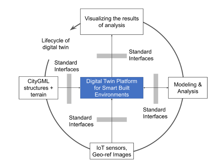
A digital twin can be thought of as a 6-dimensional geospatial model with 3 spatial axes, one phenomenon time axis, one valid time axis, and one “what-if” axis. Typically, urban digital twins represent a specific area, such as part of a city, and aspects of that area, such as its built environment, traffic flows, and air circulation. Urban digital twins usually include one or more workflows used to set and update the models they contain and sometimes include data flowing from sensors or active surveys.
The Urban Digital Twins Interoperability Pilot aims to improve the interoperability of geospatial data and analyses within digital twins and lay the foundations for better interoperability between Digital Twins developed for separate applications. To provide a useful example of how to improve interoperability, the UDTIP will focus on implementing scenarios and supporting APIs for urban noise analysis and situational analysis of geo-referenced still and moving imagery for use cases in a Smart City.
Participants in the pilot will propose solutions and prototype implementations through a collaborative innovation process.
Sponsors
The UDTIP is sponsored by the Korea Land and Housing Corporation.
Call for Participation
The Call for Participation is available here.
The recording of the Bidders Q&A Webinar, held on 14 May, 2024, is available.
Further questions may be sent via the Q&A form.
Responses to the CFP will be due by 3 June 2024, @11:59 PM AoE. All details on eligibility, benefits of participating, and how to apply will be available in the CFP document.