Federated Marine Spatial Data Infrastructure (FMSDI) Pilot
Update 6 March 2023:
The Open Geospatial Consortium (OGC) has issued the Call For Participation (CFP) for the OGC Fedated Marine Spatial Data Infrastructure Pilot 2023 (aka FMSDI Pilot Phase 4); the PDF version can be found here. Funding is available, and responses are due by April 14, 2023, @11:59 PM EST.
The Federated Marine Spatial Data Infrastructure (FMSDI) Pilot is an OGC Innovation Program initiative with the objective to enhance Marine Spatial Data Infrastructure (MSDIs), to understand MSDI maturity better and demonstrate the power of FAIR (Findable, Accessible, Interoperable, Reusable) data in the context of the marine environment.
The pilot will lead to four main outcomes.
- Demonstration – A practical technology demonstration from global community experts showcasing federated Marine SDI for selected Land/Sea use cases. Possible examples include use cases for the Arctic, European Coastal Regions, and Southeast Asian region. The demonstration will show how using OGC, IHO, and other open standards enable the community’s ability to find, obtain, use, share, interoperate, and reuse data.
- Impact on OGC Standards – Lessons learned, gaps, and the need for changes to the OGC Standards Baseline will be summarized in an Engineering Report that will inform the OGC Standards Program.
- Impact on IHO Standards – Practical testing of relevant S-100-based IHO standards will accelerate the process for the adoption and implementation of IHO standards. The resulting Engineering Report will help inform the work of the IHO HSSC Working Group and will provide inputs to enhance the framework and its component standards.
- Development of the Marine Spatial Data Infrastructure (MSDI) Maturity Model – Providing a roadmap for MSDI development.
This pilot directly responds to the recommendations from the OGC-IHO MSDI Concept Development Study (CDS) and is evidenced by the success of the OGC-IHO collaboration in the OGC-IHO Maritime Limits and Boundaries Pilot to initiate a full-scale Pilot to demonstrate a multi-country, federated Marine Spatial Data Infrastructure (SDI) under land/sea interface use-cases. This pilot further builds on OGC Arctic Spatial Data Infrastructure Pilot results. The Marine Spatial Data Infrastructure Concept Development Study summarized the efforts and information gathered from a Request for Information which focused on in-depth data requirements, architecture, and standards needs for a Marine Spatial Data Infrastructure. In addition, the Maritime Limits and Boundaries Pilot worked to build a detailed implementation to test S-121 Standard data. Finally, the Arctic Spatial Data Infrastructure Pilot aims to utilize international standards to support a spatial data exchange focusing on the complex issues of Arctic marine space. This pilot’s next phases (phases 4 and 5) are still being planned.
The FMSDI pilot started in August 2021 and is currently planned to last at least until December 2023.
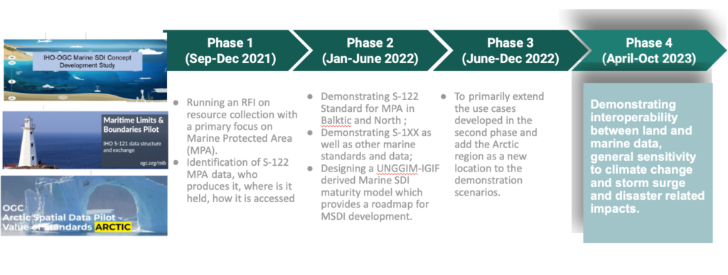
A short description of the four phases is as follows:
Phase-4: Connecting Land and Sea for Global Awareness (Active Phase)
The Call for Participation (CFP) for the FMSDI Pilot 2023 (also known as FMSDI Pilot Phase-4) was released on March 3rd, 2023, and responses are due on April 14th, 2023. This phase will include three threads in three different locations, namely Singapore, Arctic Canada and Caribbeans. The Singapore thread will focus on bridging the gap between marine and terrestrial data systems and formats to enable interoperable and integrated systems and services towards the digital twins of the land-sea interface. The Canadian thread will focus on the Arctic and the development of geospatial data integration concepts that form the future of an integrated “Digital Arctic”; efforts through this work will contribute to the fundamental understanding of efficient and powerful spatio-temporal data integration and processing platforms through concepts such as digital twins, land-sea data integration and climate change scenarios, among others. The Caribbean thread will focus on how one can contribute to a better green economy by fully exploiting land-sea geospatial information and, in particular navigation data for new use cases.
Phase-3: Connecting Land and Sea to Protect the Arctic Environment
The third phase, which started in July 2022, focused on land/sea use cases and extended the use cases developed in the second phase to add the Arctic region as a new location to the demonstration scenarios. Phase 3 advanced the implementation of open data standards, architecture, and prototypes for use with the creation, management, integration, dissemination, and onward use of marine and terrestrial data services for the Arctic. This phase includes an overarching, sea-based health and safety scenario incorporating the land/sea interface in the Arctic. And the scenario demonstrates the technology and data used with OGC, IHO, and other community standards in response to a grounding event and the evacuation of a cruise ship or research vessel in the Arctic. Incorporating the Arctic Voyage Planning Guide (AVPG) was also an important part of the phase 3 use case, where the main goal was to extend the use cases developed in the second phase of the FMSDI pilot and add the Arctic region as a new location to the demonstration scenarios. More detailed descriptions for this phase are available in HTML format. National Geospatial-Intelligence Agency supports this phase. The final Engineering Report will be available in both HTML and PDF formats. Videos and media presentations are also available as a Youtube playlist.
Phase-2: Towards a Federated Marine SDI: IHO and OGC standards applied to Marine Protected Area Data
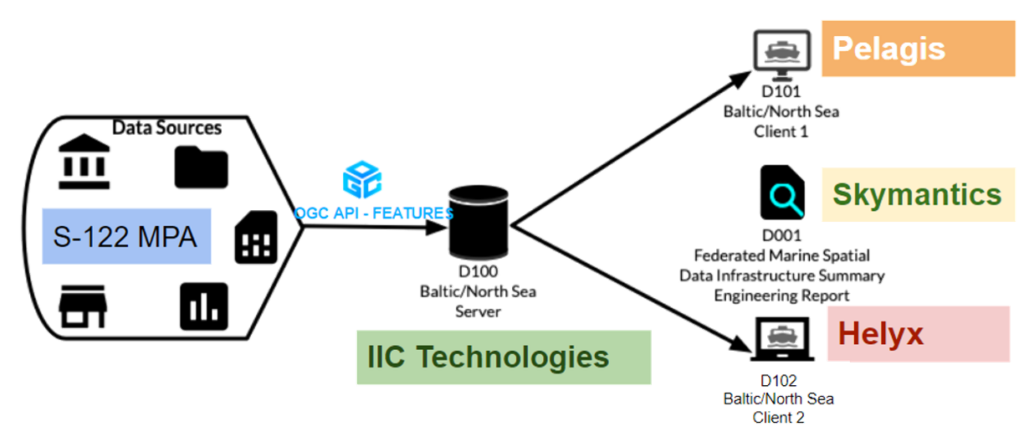
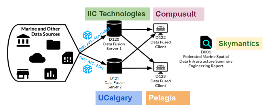
The second, already completed phase, was to further advance the interoperability and usage of MPA data by implementing the IHO standard S-122 and several OGC API standards. It described a server built to serve MPA data through an OGC API – Features endpoint and two servers that combined MPA data with additional datasets and served it through both an OGC API – Features and an OGC API – EDR endpoint. To further demonstrate the interoperability of the components, three clients were built to consume the data offered by the servers, as mentioned earlier, under different scenarios. Especially, the Baltic/North Sea use case looked at utilizing numerous Marine Protected Area data and related data to identify Marine Protected Areas within the Baltic/North Sea.
In the first thread of this phase, participants created a federation of MPA data from the various countries interested in the Baltic/North Sea region. The following image shows the participants and their role in this stage.
Then, in the Fusion overview stage, participants identified, examined, and expanded upon existing data sets to give them greater fidelity, mobility, and versatility. This stage went beyond MPA and opened the examination to a broader set of data and standards, including other data sets and standards that could be utilized to develop a firmer, more holistic view of a region. Participants and their allocated roles are presented in the following image.
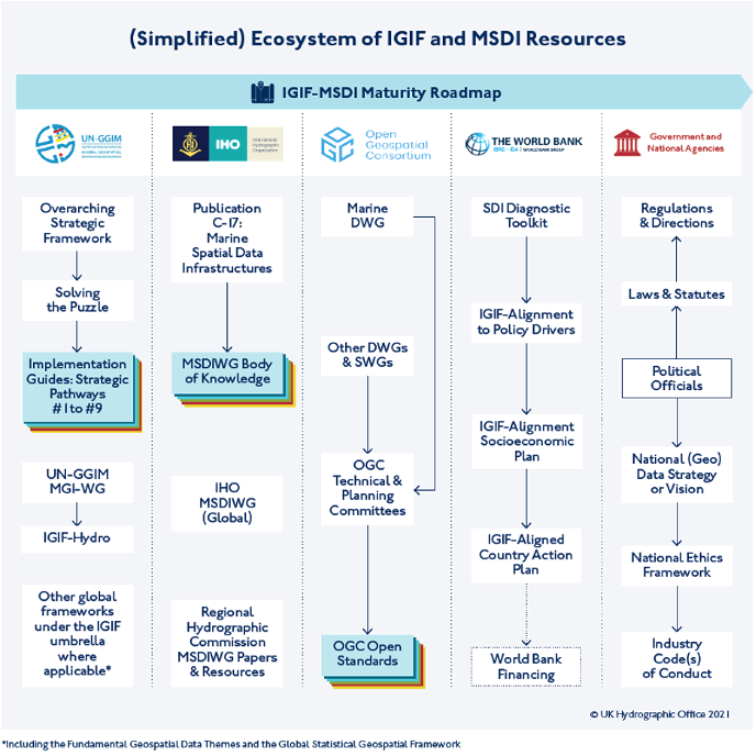
In the last stage of this phase, Integrated Geospatial Information Framework (IGIF)-MSDI Maturity Roadmap Overview, the United Kingdom Hydrographic Office (UKHO) has developed an IGIF-MSDI Maturity Framework with international contributions, highlighting that an MSDI is a continual journey and not an end-state of technological sophistication. The foundation of this initiative was the UN IGIF(IGIF, or UNGGIM-IGIF) Nine Pathways model that lays out the strategic vision and rationale for an All-Domain geospatial infrastructure (air, land, sea, and space), which equitability benefits all socioeconomic stakeholders and sectors of a nation. The IGIF-MSDI Maturity Framework was developed in conjunction with the UN, IHO, OGC and World Bank, with representation from Denmark (DGA), Singapore (Maritime and Port Authority of Singapore), and the United States (NOAA). The Engineering report for this phase is available in PDF format, and videos and media presentations are also available as a Youtube playlist.
Phase-1: Request for Information: Marine Data Availability and Accessibility Study (MDAAS)
Phase one of the FMSDI Pilot was the Marine Data Availability and Accessibility Study (MDAAS). The Request for Information (RFI) was the first part of this study to help determine data availability and accessibility of Marine Protected Areas (S-122, MPA) and other marine data in the North Sea and Baltic Sea. The RFI results were used in the second part of the study, a workshop that further refined the availability, accessibility, and lessons learned from the RFI results.
The RFI helped assess interoperability, availability and usability of data, geospatial web services, and tools across different regions and the use of marine spatial data. Along with the workshop, it also provided identification of gaps and helped define reference use-cases and scenarios for use in future FMSDI Pilot activities.
Results of the RFI responses will be analyzed and documented in a report (Annex A) that will serve as the basis of discussion for the MDAAS workshop.
In more detail, the Marine Data Availability and Accessibility Study (MDAAS) will help flush out much of the data involved in the land/sea interface scenario, coastal zone protection, shoreline management, and Marine Spatial Planning (MSP), and Marine Protected Areas (MPAs). The study will further help improve the ability to connect Terrestrial and Marine SDIs, among others. Improving Marine SDIs globally means contributing to an important and growing international collaboration that mutually benefits society in many ways:
- Improving the discovery and sharing of data within national SDIs, both terrestrial and marine, and across national jurisdictions
- Prototyping functional federated Marine SDI architecture and tools to connect to operational environments
- Building on best-of-breed standards and conventions across sponsoring and participating organizations in a highly collaborative environment to develop best practices and guidelines
- Performing real-world testing of existing IHO and OGC standards and providing recommendations for improvements to those standards
- Supporting open standards policies and improved information sharing with international partners
MDAAS started with the release of a Request for Information (RFI) to help determine data availability and accessibility of Marine Protected Areas (MPA, IHO S-122) and other marine data in the North Sea and Baltic Sea. MDAAS further helped assess interoperability, availability and usability of data, geospatial web services, and tools across different regions and the use of marine spatial data. MDAAS also provided identification of gaps and helped define reference use-cases and scenarios for use in future FMSDI Pilot activities. The results of the RFI are available in Annex A of the Phase-2 Engineering Report. And the following organizations have reached out to and participated in the RFI:
Call for Participation
The Open Geospatial Consortium (OGC) has issued the Call For Participation (CFP) for the OGC Fedated Marine Spatial Data Infrastructure Pilot 2023 (aka FMSDI Pilot Phase 4); the PDF version can be found here. Funding is available, and responses are due by April 14, 2023, @11:59 PM EST.
Sponsoring Organizations
The following OGC Member organizations so far have sponsored OGC FMSDI Pilot. The sponsors provided interoperability requirements, use cases, and scenarios. They also provided cost-share funding and geospatial data required to run the scenarios.
| Danish Geodata Agency | |
| UK Hydrographic Office | |
| National Geospatial-Intelligence Agency |
Participating Organizations
The following organizations were selected as official FMSDI participants. Each participating organization had specific deliverables and tasks based on their responses to the Call for Participation.
| Phase 3 Participants | ||
| Compusult | Canada | |
| Ecere Corporation | Canada | |
| ESRI Canada | Canada | |
| IIC Technologies UK | UK | |
| Helyx SIS | UK | |
| Tanzle | US | |
| University of Calgary | Canada | |
| Phase 2 Participants | ||
| Compusult | Canada | |
| IIC Technologies UK | UK | |
| Helyx SIS | UK | |
| Pelagis Data Solutions | Canada | |
| Skymantics, LLC | US | |
| Phase 1 Participants | ||
| Danish Geodata Agency | Denmark | |
| Finland Traficom | Finland | |
| Flemish Hydrography | Belgium | |
| Dutch Marine Information and Data Centre | Netherlands | |
| Lithuanian Transport Safety Administration | Lithuania | |
| German Federal Maritime and Hydrographic Agency | Germany | |
| Danish Maritime Authority | Denmark | |
| The Danish Environmental Portal | Denmark | |
| Swedish Maritime Administration (Swedish Hydrographic Organization) | Sweden | |
| HELCOM – Baltic Marine Environment Protection Commission | Finland | |
| UK Hydrographic Office | UK | |
| IIC Technologies UK | UK | |
| The Agency for Culture and Palaces | Denmark | |
| Geoscience Australia | Australia | |
| AusSeabed | Australia | |
| NGA (National Geospatial-Intelligence Agency) | US | |
| ESRI | US | |
Previously Closed Calls for Participation
Phase 2 of the pilot, which started in January 2022, has been finalized, and the results have been demonstrated at the 123rd OGC Member Meeting in Madrid, June 13-17, 2022. The Engineering Report and the videos are also available online. The full Call for Participation is available in HTML. A PDF version can be downloaded from here. This initiative is being conducted under the OGC Innovation Program. Proposals had been due December 10th, 2021.
Phase 3 of the pilot, which started in July 2022, has just been kicked off, and the initial results have been demonstrated at the 124th OGC Member Meeting in Singapore, October 3-7, 2022. The full Call for Participation is available here. This initiative is being conducted under the OGC Innovation Program. Proposals had been due June 24th, 2022.
Call for Sponsors
Given the multi-phased approach of this pilot, it is still possible to join the pilot as a sponsoring organization. If you are interested in sponsoring the pilot, please contact innovation@ogc.org for more information.
Last updated 2022-08-22 16:31:49 -0600
