IGIF-(M)SDI Maturity Roadmap
The OGC is pleased to host and release the first iteration of the IGIF-(M)SDI Maturity Roadmap and supporting materials for community consideration and engagement, not only across the marine domain, but across other geospatial domains where the oceans connect with or contribute to. The feedback and applied experiences from the geospatial community, via OGC meetings and forums, will be invaluable for revisions, iterations, and the optimization of the IGIF-(M)SDI Maturity Roadmap.
An independent initiative not endorsed by or officially connected to, but in alignment and support of, the mission, vision, and goals of the United Nations Initiative on Global Geospatial Information Management (UN-GGIM).
Partners and Contributors:
Direction and Sponsorship:
Support and Facilitation:
As part of the OGC’s FMSDI initiative, the IGIF-(M)SDI Maturity Roadmap as structured by the UK Hydrographic Office and international partners such as the World Bank, seeks to advance Marine and Terrestrial IGIF integration. One of the key messages therein is that an (M)SDI is a continual journey and not an end-state of expensive technological solutions. It asserts that nations are sovereign in what manner of (M)SDI they genuinely need for their national requirements, not by an externally imposed or presumed level of technological sophistication (unless otherwise chosen).
The IGIF-MSDI Maturity Roadmap The IGIF-MSDI Maturity Roadmap is being developed in conjunction via the IHO, OGC, and World Bank, with participation from the US National Oceanic and Atmospheric Administration (NOAA). As a straightforward and accessible document, its intent to provide a quantitative and prescriptive “Quick Start” or “Stepping Stone” for nations beginning an IGIF-aligned MSDI implementation. It supplements and does not replace any existing resource.
The World Bank SDI Diagnostic Toolkit with its Terrestrial heritage is augmented with IHO and OGC contributions to maximize its benefits to the Marine community, whilst being aligned with the UN IGIF principles (and UN SDGs as a result). As a guiding simplification, the involvement of the World Bank is crucial in providing answers towards the Financing question (incl. business cases), alongside Why (UN), What (IHO), and How (OGC). This aspect of measuring (socio-economic) return is commonly a key hurdle behind real-world progress.
When properly executed, the resulting MSDI Diagnostic Toolkit provides a quantitative assessment for nations or individual marine agencies to baseline their MSDI maturity, as aligned to the UN IGIF principles. The modular IHO and OGC additions ensures interoperability with the World Bank IGIF methodology, which can lead to the financing of approved MSDI development projects. Even as an independent tool, undertaking an MSDI assessment provides a clear reference point aligned with international Best Practice. Without such a starting point, progress towards any MSDI end state will be difficult to govern and manage.
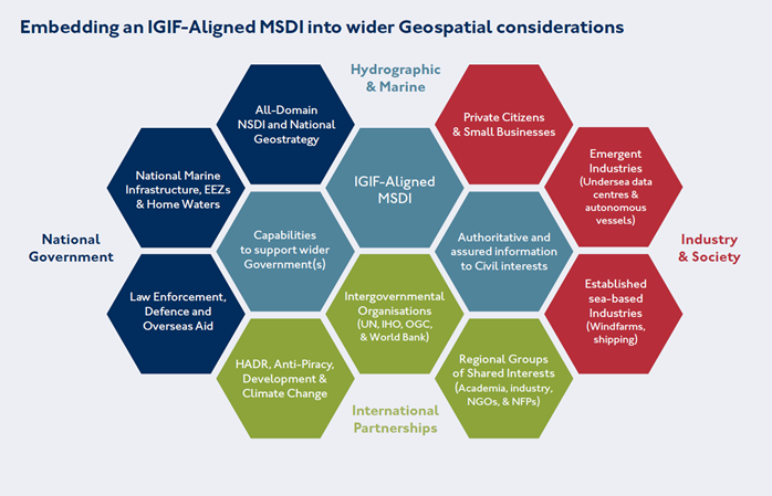
As part of the OGC’s FMSDI initiative, the IGIF-MSDI Maturity Roadmap seeks to promote the inclusive development of an IGIF-Aligned MSDI, as the marine and maritime community’s contribution to an All-Domain NSDI (across Air, Land, Sea, Space, and Cyberspace). Although initially adapted for marine considerations, the IGIF-MSDI Maturity Roadmap is fully interoperable across all geospatial domains and with the World Bank’s IGIF Methodology (with its Terrestrial heritage). It is also scalable from the national level to regions, municipalities, cities, ports, and Government departments or agencies.
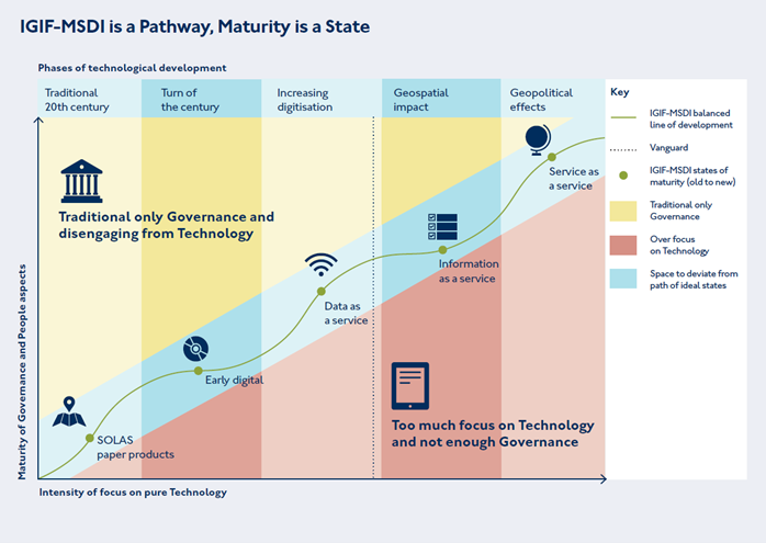
The IGIF-MSDI Balanced Pathway of Development seeks to promote inclusive geospatial development via two key messages of “Driving Technology, not being driven by Technology” and “Making the Data count, not just counting the Data”. These twin ideas promote the effective governance of Technology and Standards to meet sovereign national requirements, however expansive or constrained, over the acquisition and possession of the latest technological solutions independent of cost-benefit considerations.

The Open Geospatial Consortium (OGC) contributes to the IGIF-MSDI Maturity Roadmap by providing key considerations around the implementation of Standards, alongside an active cross-sector global forum to share applied knowledge, cooperate on emerging technologies, and collaborate on standards development. The engagement of the OGC membership is vital for the realisation of cost-benefits stemming from common implementation across different countries, regions, applications, and socio-economic domains.

Example of radar chart output across 9 assessment categories, corresponding to the IGIF Nine Pathways, for an initial baseline and a subsequent baseline (two-years following). The underlying data is from real-world assessments taken under World Bank and partner oversight, which was openly published by the Agency for Land Relations and Cadastre of the Republic of Moldova.
As an OGC Strategic Member and a sponsor of the OGC’s FMSDI initiative, the United Kingdom Hydrographic Office (UKHO) is the UK’s agency for providing hydrographic and marine geospatial data to mariners and maritime organisations across the world. The UKHO is responsible for operational support to the Royal Navy and other defence customers. Supplying defence and the commercial shipping industry, they help ensure Safety of Life at Sea (SOLAS), protect the marine environment, and support the efficiency of global trade. Together with other national hydrographic offices and the International Hydrographic Organization (IHO), the UKHO works to develop and raise global standards of hydrography, cartography, and navigation. The UKHO also produces a commercial portfolio of ADMIRALTY Maritime Data Solutions, providing SOLAS-compliant charts, publications and digital services for ships trading internationally.
Overview
Lorem ipsum dolor sit amet, consectetur adipiscing elit. Quisque ac diam bibendum, tincidunt magna in, fermentum tortor. Ut maximus, diam id consequat tincidunt, tortor ligula porta dui, vel vestibulum tortor nisi vitae enim. Vivamus quis ante id magna egestas accumsan quis vel augue.
