• Member login
  • Contact
twitterlinkedinyoutubediscord
Open Geospatial Consortium
  • Key topics
        • Defense and Intelligence
        • Climate Change and Disaster Resilience
        • Marine Geospatial
        • Smart Cities
        • Metaverse
        • Cloud Native Geospatial
  • About
        • OGC Member List
        • Board of directors
        • Staff
        • Committees
        • Domains
        • Community
        • Regions and forums
        • Alliance partners
        • Become a member
        • OGC Awards
        • Policies
        • Careers
        • Contact
  • Innovation
        • Active Initiatives
        • Completed Initiatives
  • Standards
        • Standards
          • API’s
          • Standards roadmap
          • Abstract specification
          • Community standards
          • Naming Authority Policy Documents
          • OGC Reference Model (ORM)
  • Resources
        • Compliance
          • Implementations
          • Certified products
          • Uncertified products
          • Implementations by standard
          • Compliance Roadmap
        • Papers & Reports
          • Best practices
          • Community practices
          • Engineering reports
          • Discussion papers
          • Technical papers
          • Change requests
        • OGC Requests (RFCs, CFPs...)
        • OGC Developer Website
        • OGC RAINBOW
        • Guide for software acquisition
        • Contact Us
  • News
  • Events
  • Become a member

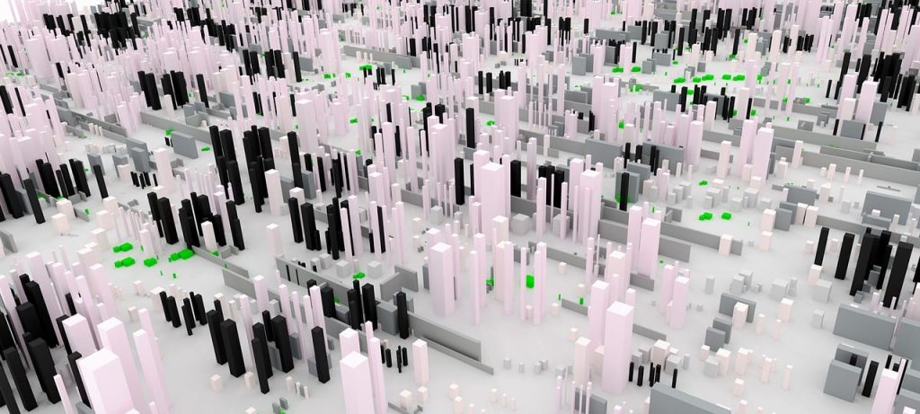
Related Content: 3D Data

April 25, 2022

OGC Seeks Public Comment on update to 3D Tiles Community Standard

3D Tiles enables sharing, visualizing, fusing, and interacting with massive heterogenous 3D geospatial content across desktop, web, mobile, and metaverse applications.

OGC adopts CityGML 3.0 part 2 GML encoding as official standard
July 28, 2023

OGC adopts CityGML 3.0 Part 2: GML Encoding as an official OGC Standard

New encoding for CityGML version 3.0 can be used to store and exchange 3D city models in the GML format as data sets or via web services.

January 10, 2023

OGC Testbed-18

OGC Testbeds are OGC’s largest Innovation Program initiatives. Testbeds boost research and development to make location data and information more FAIR: Findable, Accessible, Interoperable, and Re-Usable. Testbeds provide a unique opportunity for sponsors to tackle location data and processing challenges together with the world’s leading geospatial IT experts.

Sign up today

Receive the latest news on OGC.

Click here to sign up
  • About
    • Board of directors
    • Committees
    • Staff
    • Careers
  • Innovation
    • Active Initiatives
    • Completed Initiatives
  • Standards
    • Best practices
    • Discussion papers
    • Implementations
    • Compliance
  • Privacy Policy
  • Media guidance
Open Geospatial Consortium

2300 Wilson Blvd. Suite 700-1026
Arlington, VA 22201, USA

+1 508 655 5858

Follow us

twitterlinkedinyoutubediscord

© 2023 Open Geospatial Consortium. All Rights Reserved.

Become a memberBecome a member