


To promote the prosperity and security of citizens, governments at all levels in all countries provide infrastructure of various kinds. Managing physical infrastructure requires communication and information infrastructure. Spatial Data Infrastructures (SDI) play an important role, because location information is important in managing everything that governments manage, from such as roads and sewers to education and public health. Like most types of infrastructure, SDIs also provide a platform for economic development. The OGC is one of the standards organizations most responsible for the success of 21st century SDIs.
The definition of Spatial Data Infrastructure (SDI) has changed little since the term first started to be used in the early 1990s: Spatial Data Infrastructure is the “… collection of technologies, policies and institutional arrangements that facilitate the availability of and access to spatial data.” The technologies, however, have been changing dramatically and will continue to change. Wise 21st Century government policy makers know that they must adapt policies and institutional arrangements to accommodate and take advantage of these technological changes.
OGC standards and complementary standards from the International Organization for Standardization (ISO) Technical Committee 211 (Geographic information/Geomatics) are essential elements in SDIs around the world. This is because SDIs are data and service networks, and networks depend on open standards. Making policies that maximize the use geospatial products, solutions and services that implement these standards is the best way to maximize the return on these investments.
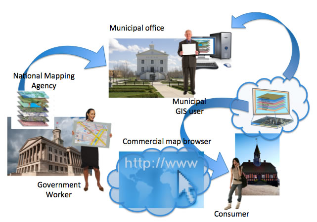
Most government information has a geospatial component, and at all levels of government significant resources go into gathering and coordinating geospatial information. Policies vary from country to country and jurisdiction to jurisdiction, but usually governments choose to be primary providers of some types of authoritative geospatial information while coordinating and managing other types of geospatial data through partnerships. Without SDI programs that structure cooperative efforts, expensive duplication of effort is the rule rather than the exception as offices, agencies, citizens and private sector stakeholders seek to obtain the data they need to accomplish their objectives.
“Interoperability seems to be about the integration of information. What it’s really about is the coordination of organizational behavior.” David Schell, Founder and Chairman of the OGCNational mapping agencies have played an important role in SDI development, but, whereas in the past the word “National” usually preceded the phrase “Spatial Data Infrastructure,” that is no longer the case. Government officials recognize that national spatial data infrastructures are made up of many local and subnational spatial data infrastructures. With a broad commitment to interoperability through open standards, an investment within one jurisdiction becomes an investment that serves all related jurisdictions. Different kinds of data are best maintained at different levels of government. With open standards, such distributed responsibility works well, enabling government data sharing partners and private sector stakeholders to easily access the most up-to-date data.
Recognizing the importance of SDI at all levels of government, in 2011 the OGC created a new OGC GovFuture membership that offers local and subnational government agencies worldwide a new way to maximize the value they receive from their investments in geospatial information and related technology. GovFuture helps decision-makers in local and subnational governments understand open standards and use them to best advantage.
SDI architectures have changed with the rapid advance of technology and the open standards infrastructure that enables the Internet and the Web. Geospatial data is still at the heart of every SDI, and data coordination will always be an important SDI activity. However, “technical interoperability” enabled by open standards has changed workflows and made institutional coordination easier.
The OGC’s software interface and encoding standards, now widely implemented by software vendors, make many things possible. Some examples: Different vendors’ systems can exchange instructions over networks, eliminating the need to standardize on a single vendor’s software. “Best of breed” software components from different vendors can be integrated into solutions. Legacy systems “wrapped” in open interfaces can be profitably kept in service longer, and new systems and add-ons can be purchased with less risk of obsolescence. Data and services from countless sources can be accessed by Web clients. Each year new standards from the OGC and other standards development organizations extend the possibilities of Web-based SDIs.
SDI managers have more viable options to choose from than ever before. A desktop GIS can still serve its original purpose, but it can also be put online so its users can access remote data and so it can be a Web-accessible source of managed data and Web services. These resources can be registered with metadata in online catalogs so they can be easily discovered and assessed. Departmental systems can similarly serve the needs of local and remote users. Today, it is easy to tap into feeds from online geolocated sensors or updates from remote data servers. In all of these use cases, much less custom integration is necessary than before because open standards enable systems to “plug and play.”
Client applications and in some cases server processes can now run on handheld devices as easily as on desktop systems. Smart phones and other mobile devices make many new applications possible. For example, motion sensors in the phones of city employees could detect bumps in the road and autonomously transmit the data to a road maintenance department data collection. Data can be stored locally or it can be stored on remote departmental servers or on the “cloud” servers at a remote data center managed by a cloud service provider.
Cloud computing is a trend resulting from a convergence of technologies such as broadband communications, virtualization, and Web services. It supports service-oriented architectures based on OGC Web Service standards, enabling government geospatial IT departments to downsize by moving data and perhaps also software platforms, tools and software to remote data centers.
National mapping agencies, state and provincial GIS centers, data coordination councils and regional and municipal geospatial data authorities cannot, for very long, continue to operate as they did a few years ago. Leaders need to look at what is now possible that was not possible before, considering capabilities such as cloud computing, crowdsourced data collection, social networking, reverse 911, sensor webs, 3D urban models, building information models (BIM), LIDAR and new Web-accessible services that provide, sometimes at no cost, many of the services that previously could be obtained only from local GIS experts. These authorities need to talk to vendors and gather information about new capabilities, reconsider agency missions and goals, review and revise policies, make budget and human resource decisions, and vet new products, cloud services, and cloud service providers.
In this environment of rapid technological change, SDI managers also need to stay in close communication with stakeholders and data sharing partners. SDIs are, after all, data and service networks connecting many nodes that exchange spatial information by accessing each other’s data and services.
Open standards enable such exchanges to take place in real time, and the progress of open standards enables more and more data management functions to be automated. The OGC Candidate GeoSynchronization Service Standard, for example, describes an open standard interface to a software service that allows data collectors to propose changes to be made to a data provider’s geospatial features (such as data about property lines, city population, vehicle location, etc.). A change proposal can be made to create new data or to modify/delete existing data. Proposed changes are reviewed (either manually or automatically) and are either accepted or rejected. Accepted changes are applied to the appropriate repositories. The service also maintains a log of all changes applied to each feature.
The key point here is that this is an open standard. Veteran GIS experts can easily imagine such capabilities being implemented as part of a single vendor solution. What’s new is that once this standard has been implemented by multiple vendors, then data sharing partners around a city, province or country will not need to standardize on one particular vendor to benefit from geosynchronization. Experience with OGC standards (there are now more than 20 widely deployed OGC standards) suggests that a wide variety of companies will implement the standard as soon as it is adopted: database software vendors, decision support and business intelligence solution providers, app developers and others. This gives purchasers many options, because all of these standards-compliant products and services can easily work together, just as if they were integrated solutions from one vendor or one integrator .
The variety of standards-enabled options underscores the need for purchasers to gather information about the standards implemented in software products and services. Also the importance of the standards underscores the need to know that they have been correctly implemented. To help organizations meet these needs, the OGC provides education and outreach through the GovFuture program and provides compliance testing and certification through the OGC Compliance & Interoperability Testing & Evaluation (CITE) program.
The OGC created GovFuture to help decision-makers in local and subnational governments understand and benefit from the application and use of open standards. This affordable membership level is focused on applying and using OGC standards, not developing them. GovFuture membership can help local and subnational governments:
The OGC Compliance & Interoperability Testing & Evaluation (CITE) program, also known as the OGC Compliance Testing Program, serves to increase systems interoperability while reducing technology risks. This program provides a mechanism by which users and buyers of software that implements OGC standards can be certain that the software follows the mandatory rules of implementation as specified in the standard. Vendors gain confidence that they are providing a product compliant with OGC standards, which will be easier to integrate and easier to market. Buyers gain confidence that a compliant product will work with another compliant product based on the same OGC standard, regardless of which company developed the product.
Government organizations have always played an important role in the OGC. Government members are able to voice their interoperability needs directly to a broad and global industry, academic and government community. In the OGC, vendors, integrators and platform providers build interoperability interfaces and encodings far faster than is possible with traditional system integration contracting, and the benefits are shared globally. With the rapid advance of geospatial technology and technologies such as social networking and mobile apps, much work remains to be done with other users in the OGC process to demonstrate the need for and potential market appeal of new standards. Small resource investments by technology users in the OGC’s consensus processes often result in vendors’ willingness to address and then broadly implement OGC standards in their products.
Users benefit first by expressing their interoperability requirements in the OGC standards development process, and then by adopting procurement language that calls for OGC standards in products to be considered for purchase and deployment. There is no better forum than the OGC for staying abreast of the latest technology policies.
To learn more about what the OGC is doing and how your organization can benefit from participation, contact: http://www.opengeospatial.org/contact.
See the OGC Requests Page for information about candidate standards for which the OGC seeks public input and interoperability initiatives for which the OGC seeks quotations and participation.
Domain Working Groups provide a forum for discussion of key interoperability requirements and issues, discussion and review of standards, and presentations on key technology areas relevant to solving geospatial interoperability issues.
Standards Working Groups have specific charter of working on a candidate standard prior to approval as an OGC standard or on making revisions to an existing OGC standard.
OGC Alliance Partners are organizations whose missions are aligned with the OGC mission. Many of these organizations work with us on standards development, particularly when an interoperability solution depends on consistency between standards from different standards development organizations. Standards organizations look to the OGC for advice on how to encode geolocation in their standards and we look to them to learn what we must do to achieve harmonization across the standards stack.
Selections from the OGC Press page: press coverage, blogs & papers:
We represent over 500 businesses, government agencies, research organizations, and universities united with a desire to make location information FAIR – Findable, Accessible, Interoperable, and Reusable.


Receive the latest news on OGC.
© 2024 Open Geospatial Consortium. All Rights Reserved.