


Geographic location is usually a critical factor in business research and calculations about customers, suppliers, distributors, natural resources, transportation hubs, energy and most other things. Business intelligence platforms and applications need to help users find, use and communicate location information, so it follows that digital standards for system-to-system communication of geospatial information are a critical enabling factor for better business intelligence. The OGC is the organization that can turn GeoBI user requirements into standards that BI vendors implement to take advantage of the rapidly growing ecosystem of interoperable Web-based spatial data and services.

GeoBI is business intelligence that makes use of geospatial information. Business intelligence supports better business decision making leading to new revenue opportunities, improved cost visibility, and better risk management. Business intelligence (BI) refers to computer-based techniques used for identifying, extracting and analyzing business data, such as sales revenue by products and/or departments, or by associated costs and revenues. Common functions of business intelligence technologies are reporting, dashboards, scoreboards, online analytical processing (OLAP), data mining, process mining, business performance management analytics and predictive analytics.
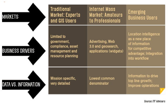
Traditional geographic information systems (GIS) and image processing software products provide powerful techniques for dealing with geospatial data in geospatial-centric applications, but geospatial data and processing are no longer confined to those products. With the advent of the Web, and partly due to OGC standards, geospatial data has become an enabler for many mass-market applications, such as Web mapping and location based services (LBS). Much less expertise is now required to use geospatial information for business tasks (See Figure 1).
Figure published in Imaging Notes, Fall 2008 – http://www.imagingnotes.com/go/
Figure 1 – Beyond Traditional GIS/Imagery and Mass Markets[1]
Increased use of OGC standards in the location intelligence marketplace and within the business enterprise can provide technology users with a basis for improved decision making and greater product choice. More Intranet and external Internet resources become directly accessible. In large enterprises and merged enterprises, standards help bridge dissimilar systems. Technology providers also benefit because standards help providers reduce development costs, integration costs and time to market, and standards often open up new opportunities for business partnerships.
The OGC’s open standards make it possible for geospatial information from many sources to be used with business applications of many kinds. Below are some example value propositions showing the usage of geospatial information and business intelligence in decision making:[2]
OGC standards are frequently implemented in business applications. For example, the OGC Simple Features Access (SFA) Encoding Standard provides interoperability for geospatial features using SQL—the query language of databases that serve the business market. The OGC’s Web Map Service (WMS), Web Feature Service (WFS) and Web Coverage Service (WCS) interface standards provide access to geospatial information based upon service-oriented architecture—a main method for internet-based business.
In 2005, OGC began work on the Web Processing Service (WPS) Interface Standard—an interface that allows any computational process to be exposed as a Web service—thereby adding a focus on online analysis and geoprocessing to the OGC’s traditional data access and query standards. Also in 2005, the OGC Mass Market working group was established to address the market swing to web-based and LBS consumer applications.
OGC Innovation Program initiatives – testbeds, pilot projects and interoperability experiments – are global, hands-on collaborative prototyping activities designed to rapidly develop, test and deliver proven candidate specifications into the OGC’s Standards Program, where they are formalized for public release as OGC standards.
Business intelligence stakeholders – technology users and providers – will find opportunities to partner with other OGC members in the Innovation Program. For example, military intelligence agencies and contractors in the OGC have been using OGC testbeds and pilots to advance data fusion using unstructured geospatial data on the Web. The requirements that drive these activities are not too different from the requirements of online transaction processing (OLTP) in many business intelligence applications.Scores of interoperability use cases and scenarios are reviewed in the OGC every quarter, and members all have the opportunity to participate in these discussions and contribute interoperability requirements.
Business intelligence solution providers and platform providers as well as business intelligence users might ask the OGC membership to help:
So far, business intelligence has relied on geospatial standards developed by other communities of interest. As specific business intelligence interoperability requirements become more apparent, the ways in which business intelligence players can profit from OGC membership also become more apparent.
OGC Technical Committee Domain Working Groups provide forums for discussion of key information system interoperability requirements and issues, discussion and review of standards, and presentations on key technology areas relevant to solving geospatial interoperability issues. Members, both technology providers and technology users, derive many benefits from working together to resolve interoperability issues.
A number of organizations are interested in creating an OGC business intelligence domain working group. Such a group will tackle problems of immediate and strategic interest to the business intelligence community. Contact us if you are interested in becoming a founding member of this working group.
There are other working groups relevant for business intelligence. For example, the OGC Mass Market working group was established to address the market swing to Web-based and location based services consumer applications. Some of the other domain working groups relevant to business intelligence are the Geosemantics DWG, the Workflow DWG and the Decision Support WG. Enterprise business issues are topics in other OGC Domain Working Groups, such as the 3DIM DWG (urban 3D models, building information models, indoor location etc.), Data Preservation DWG, Data Quality DWG, Geo Rights Management DWG, Location Services DWG, Security DWG, and Sensor Web Enablement DWG.
Domain Working Groups are part of the OGC Standards Program. Working Group objectives are also served by the OGC Innovation Program, Compliance Program and Marketing and Communications Program.
The OGC maintains alliance partnerships with many standards development organizations and industry associations to ensure that OGC standards work well with other standards and to ensure that OGC standards meet user requirements across a broad spectrum of domains and applications. Many of these, such as the World Wide Web Consortium (W3C) and the Organization for Advancement of Structured Information Standards (OASIS) provide standards essential to networked business intelligence applications.
http://www.b-eye-network.com/view/462
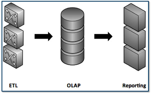
Figure 2: Components of business intelligence systems
The three main components of BI systems are ETL (extract, transform, load), OLTP (online transaction processing)/OLAP (online analytical processing) and reporting (which includes dashboards and applications).
At the ETL stage, location data can occur in many forms ranging from a word with implicit geographic meaning (Paris) to explicit coordinates defining a location in a mathematical fashion (latitude-longitude coordinates). Geographic standards provide definitions of geometry, describing physical objects such as buildings, town boundaries, sales territories, voting districts, rainfall patterns, hurricane paths, etc. BI systems are optimized for speed, and therefore large-scale enterprise systems typicallymaintain data in unique, idiosyncratic and often proprietary formats
OLTP systems facilitate and manage transaction-oriented applications. OLAP systems “crunch” and “slice and dice” data for reporting applications and dashboards. Dashboards are typically web sites that organize information so that it is easy to read and interpret. Dashboards provide up-to-date status information and options for performing various kinds of analyses and data displays.
At the OLAP/OLTP stage, when data is ready to be analyzed, human-centric geospatial terms such as street addresses must be translated into physical geometry to support efficient data processing such as aggregation, statistical analysis, and computational modeling.
Finally, at the reporting and visualization stage, a different model of location information may be appropriate to take into account the focus shift from data processing to display.
It is important to note that competition, niche providers, cloud computing and other factors are driving the costs of BI down, so that more and more small to medium size business are embracing BI solutions. As a result, more and more unstructured data from diverse sources is being used. This trend both benefits from and helps drive the trend toward standards, including geospatial standards.
OGC membership provides a cost-effective way for technology users and providers to influence and track the progress toward a fully spatially enabled 21st century business intelligence information environment.
Effective standards development involves participation by companies that develop software products that implement the standards, but it is also the case that consumers of GeoBI – the persons making critical decisions based upon GeoBI – must be involved. The OGC invites additional participation in the consensus process and also invites technical queries related to new implementations of the emerging standards.
See the OGC’s Requests Page for information about candidate standards for which the OGC seeks public input and interoperability initiatives for which the OGC seeks quotations and participation.
Membership in the OGC offers many benefits to both your organization and the larger geospatial community. We invite you to learn more. Contact: info@opengeospatial.org.
We represent over 500 businesses, government agencies, research organizations, and universities united with a desire to make location information FAIR – Findable, Accessible, Interoperable, and Reusable.


Receive the latest news on OGC.
© 2024 Open Geospatial Consortium. All Rights Reserved.