


Stakeholders at every stage in the life cycle of buildings and other capital projects depend on information systems. From initial design concept to final demolition, spatial information plays a role, but communicating spatial information between systems is often problematic, and thus the systems frequently fail to deliver their anticipated value.
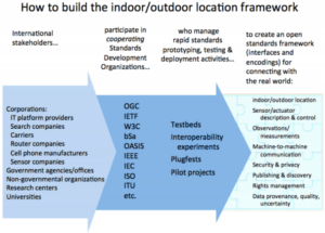
The OGC, working with other standards organizations and industry associations, develops open standards to support productivity across the supply chains of the building design, physical infrastructure, capital project and facilities management industries. All of these domains are poised for rapid change as indoor/outdoor location technologies, mobile devices, optical imaging, augmented reality, sensor/actuator webs and other technical advances seek applications. Open standard ways of communicating position and geometry – and helping location information flow – can facilitate this progress.
The OGC 3D Information Management Working Group is becoming an important focus for the convergence of the necessary standards. One reason is that major CAD and GIS software vendors are already involved in the OGC’s consensus process. So are U.S. federal agencies, including the Army Corps of Engineers, the US National Institute of Building Sciences (NIBS), the Federal Geographic Data Committee (FGDC), the National Geospatial-Intelligence Agency, and the Department of Homeland Security.
European governments have also shown interest. The German North Rhine Westphalia Sig3D organization originally developed CityGML, now a globally important OGC standard for sharing urban models and integrating design drawings with spatial data. CityGML provides a standard model and mechanism for describing 3D objects with respect to their geometry, topology, semantics and appearance, and defines five different levels of detail. Though CityGML is focused on 3D modeling, it also provides a practical standard way to integrate indoor/outdoor location, that is, a standard way to integrate building location in Earth coordinates with building details in the Euclidean geometry of Computer Aided Design (CAD) systems. CityGML is now being widely implemented in software products and online services. It is the standard for 3D geo-information in the Netherlands and CityGML 3D models are being built or considered by many countries.
The OGC 3D Information Management Working Group is specifically focusing on facility planning, emergency management, asset management, and navigation. All of these involve convergence of technologies: 3D visualization, CAD-GIS integration, Building Information Models (BIM), Industry Foundation Classes (IFC), Information Delivery Manuals (IDM), Model View Definitions (MVD), Web services, security, and digital rights management. Standards are an important enabler of such convergence.
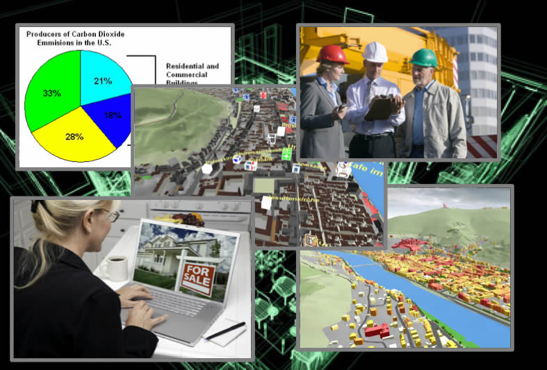
The building industry is a huge complex of value chains, workflows, vocabularies, customs and regulations, different in every country. Every building and every building project touches many professionals, companies and official bodies, and these people and organizations need to exchange spatial information on a daily basis. Such information includes computer-aided design (CAD) data, facilities usage data, civil engineering data, zoning data, floor plans, appraisals, written information and much more.
‘Communication’ means ‘transmitting or exchanging through a common system of symbols, signs or behavior’, and ‘standardization’ means ‘agreeing on a common system’. We have much more communication in the world today because we have much wider use of common digital interfaces and encodings. However, for lack of a common digital “language” of open software interface and data encoding standards, tens of billions of dollars (in the US alone) are spent converting, recreating and searching for building-related data. This waste translates into extraordinary lost opportunities for society.
Since 1994 the OGC has been bringing diverse companies, research groups and government organizations together to develop interface and encoding standards that solve industry problems related to sharing geospatial information. The OGC’s scope is expanding. New initiatives address the location interoperability requirements inherent in emerging domains of technology and activity such as the Internet of Things (IoT), Machine-to-Machine (M2M) communication, optical imaging, Augmented Reality (AR), indoor navigation, embedded mobile devices, and social networking. These developments will impact traditional workflows and value chains in the “architecture, engineering, construction, owner, operator” (AECOO) industry. New industries, such as location-based marketing and the smart grid, are creating both demand for data and new sources of data about buildings, shopping areas, and infrastructure. The OGC IndoorGML standard has opened the door to countless indoor navigation applications. Location interoperability in all of these domains requires much better cross-technology, cross-vendor integration of indoor and outdoor location information than is currently possible.
The Open Geospatial Consortium (OGC) Land And Infrastructure Domain Working Group (LandInfraDWG) is developing a new candidate standard – the OGC InfraGML Encoding Standard – that provides a use case driven subset of LandXML functionality, but that is implemented with the OGC Geography Markup Language (GML) and supported by a UML (Unified Modeling Language) conceptual model.
OGC interoperability initiatives – testbeds, pilot projects and interoperability experiments – are part of the OGC’s Innovation Program, a global, hands-on collaborative prototyping program designed to rapidly develop, test and deliver proven candidate specifications into the OGC’s Standards Program, where they are formalized for public release.
OGC testbeds and interoperability experiments have advanced standards and best practices for publishing and streaming 3D geospatial assets related to urban planning and landscape visualization. Participants have studied the tradeoffs between construction cost and energy efficiency and demonstrated how open standards can reduce energy analysis turnaround time from weeks to days. Scenarios have included searches of building 3D models to find a site for an emergency hospital, and the use of open 3D models to locate hazardous chemical storage areas during fires.
The OGC has developed an efficient process for convening diverse stakeholders and helping them quickly develop internationally useful interoperability standards that serve everyone.
Designers, builders, owners and operators of buildings and capital projects increasingly look to the OGC to help them solve an array of spatial information integration challenges that cannot be met by the offerings of any single technology provider. These technology users see that they need to unite to bring progress in this area.
Technology providers cooperate with each other and with user organizations in the OGC partly to build the elements of a standards platform that expands their markets, partly to stay close to important customer groups, partly to stay at the forefront of technology, and partly to share the cost of developing open interfaces and encodings that free up their developers for more valuable work.
The OGC maintains alliance partnerships with many standards development organizations and industry associations to ensure that OGC standards work well with other standards and to ensure that OGC standards meet user requirements across a broad spectrum of domains and applications. OGC Alliance Partners involved in the built environment and 3D include:
The OGC works with standards development organizations like the World Wide Web Consortium and OASIS because their standards provide a necessary foundation for spatial standards, and working with these organizations reduces the likelihood that competing or incompatible interoperability approaches will emerge.
No single standards organization can provide all the pieces of the AECOO interoperability puzzle, but by working together they can first create a shared vision and a roadmap and then begin putting the pieces together. By working with other organizations that understand the requirements of particular sectors of the AECOO industry, the OGC staff and membership can efficiently gather and share knowledge of such requirements to help address those requirements.
The strategic agendas of OGC members drive progress toward interoperability and technology convergence. Different communities of practice and communities of interest have different needs and agendas, but often these communities’ needs and agendas overlap. Participating in OGC activities facilitates multi-community and cross-domain cooperation and cost sharing, and implementing OGC standards directly improves data sharing.
For sound business reasons, hundreds of public sector, private sector and academic organizations from countries around the world have dedicated resources for the last sixteen years to create open standards in the OGC. Their representatives’ work and OGC’s cooperation with other standards organizations have enabled the location interoperability that network-centric operations demand. We encourage you to visit http://www.opengeospatial.org/contact to learn how participation in the OGC can help your organization achieve its objectives.
We represent over 500 businesses, government agencies, research organizations, and universities united with a desire to make location information FAIR – Findable, Accessible, Interoperable, and Reusable.


Receive the latest news on OGC.
© 2024 Open Geospatial Consortium. All Rights Reserved.