


To improve air travel safety and operational efficiency, the global aviation community is moving forward on the adoption of an international framework of standards that enable communication in a net-centric, globally interoperable Air Transport System (ATS). Because location information is critical in virtually all aviation activities, location interface and encoding standards from the OGC play an important role.
Several of the world’s major government aviation organizations working with large and small aviation companies are now far along in the development and adoption of the Aeronautical Information Exchange Model (AIXM) and the Weather Information Exchange Model (WXXM). Both standards make use of the OGC Geography Markup Language (GML) Encoding Standard. The OGC, through its Innovation program, has been assisting in the evaluation, advancement and adoption of AIXM and WXXM by leading a series of rapid prototyping testbeds focused on these emerging standards.
The OGC Technical Committee Aviation Domain Working Group provides a forum for discussion of key aviation information system interoperability requirements and issues, discussion and review of standards, and presentations on key technology areas relevant to solving geospatial interoperability issues. The Aviation DWG is not only a forum for discussions but is also chartered to deliver materials such as discussion papers and best practices for aviation. It is the appropriate body to capture aviation-related requirements that feed into the OGC/ISO standardization loop. Members, both technology providers and technology users, derive many benefits from working together to resolve Aviation interoperability issues in this forum. The Aviation DWG is open to both OGC members and organizations that are not OGC members. Opening participation to organisations not belonging to the OGC strengthens the role of the ADWG as a federating body for Aviation-related information management (IM) issues.
The Aviation Domain Working Group is part of the OGC Standards Program. Working Group objectives are also served by the OGC Interoperability Program, Compliance Program and Marketing and Communications Program, as described on the OGC Programs page. Some of the other OGC domain working groups relevant to aviation are the Geosemantics DWG, Workflow DWG, Meteorology & Oceanography DWG and Decision Support WG.
The OGC maintains alliance partnerships with many standards development organizations and industry associations to ensure that OGC standards work well with other standards and to ensure that OGC standards meet user requirements across a broad spectrum of domains and applications. OGC Alliance Partners involved in aviation work with the OGC include the Network Centric Operations Industry Consortium (NCOIC), the World Meteorological Organization (WMO) and others. OGC Europe has been recently appointed as a Joint Single European Sky ATM Research Joint Undertaking (SESAR JU) Associate Partner for the IM domain.
The US Federal Aviation Administration (FAA), EUROCONTROL, the US National Geospatial-Intelligence Agency and other organizations are now far along in the development and adoption of the Aeronautical Information Exchange Model (AIXM), with support from aviation industry representatives such as Fedex, Frequentis and Lufthansa. AIXM is a standard designed to enable the management and distribution of Aeronautical Information Services (AIS) data in digital format. AIXM takes advantage of existing and emerging information engineering standards to meet aeronautical information system requirements, particularly those related to the highly spatio-temporal nature of aeronautical information.
AIXM 5 is based on the OGC Geography Markup Language (GML) Encoding Standard to ensure alignment with international standards for location information and to ease its adoption by technology providers that already support GML in their Commercial Off The Shelf (COTS) products.
Similarly, the Weather Information Exchange Model (WXXM) is being developed as a standard for the exchange of weather information in support of aviation meteorology (MET) domain requirements. WXXM is also based on GML, and implements the OGC Observation and Measurement Model (O&M) Encoding Standard. WXXM development is harmonized and coordinated with the World Meteorological Organization (WMO), the organization traditionally responsible for standards in meteorology.
Core standards from the OGC and the International Organisation for Standards (ISO) are critical for transitioning to a net-centric, global aeronautical management capability. An OGC/ISO process is in place for standards from the OGC to become ISO standards, and this is considered essential in the context of SESAR.
The OGC has been assisting in the evaluation, advancement and adoption of AIXM and WXXM by leading a series of rapid prototyping testbeds focused on these emerging standards. The testbeds, managed under the OGC Innovation Program, help advance, align and profile the standards and help develop new ones (such as the OGC Event Service Interface Standard) to meet the needs of aviation data producers, users and managers.
Testbeds, pilot projects and interoperability experiments are the backbone of the OGC’s process for coordination, alignment, profiling, development and promotion of OGC standards. Every year, a major OGC Web Services (OWS) testbed initiative brings diverse technology users together with technology providers to undertake this work. Each testbed involves multiple technology “threads.” With sponsorship from FAA and EUROCONTROL, an Aviation thread was introduced in OWS-6 (2009) and OWS-7 (2010) to further increase industry adoption of AIXM and WXXM and to support the operational use and validation of these emerging standards. This work continues in the aviation thread in OWS-8 (2011), which will culminate in a closer alignment of OGC standards to the needs of the Aviation community and will result in significant contributions to AIXM and WXXM. The outcomes of OWS-8 will include a series of Engineering Reports detailing the contributions, and final demonstrations planned at the end of 2011.
AIXM is being used in the net-centric System Wide Information Management (SWIM)-related components of the US NextGen and European Union (EU)’s SESAR programs. The results of the Aviation Thread of the OWS-7 testbed have been contributed to both programs with a focus on recommended OGC specifications that can be applied in the definition and implementation of both SWIM environments.
OGC is also leading a pilot project sponsored by the FAA to increase dissemination of Special Activity Airspace (SAA) information to its National Airspace System (NAS) stakeholders via OGC Web Services. This work will result in documentation of the use of OGC Web Services in System Wide Information Management (SWIM) environments.
Corridors
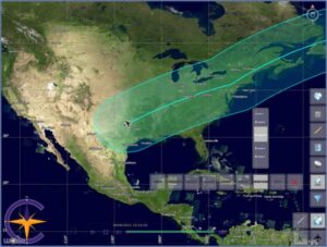
Imagine the weather forecast for the entire flight 3 legged flight route: from Brussels to Helsinki to Rome. If I were to use the standard bounding box approach this would need an enormous 4d box – dLat x dLon x dLat x dTime. Whilst we only need to weather along the route at a moment in time and place (including altitude). Users typically only require data along the route.
The OGC GetCorridor service allows to define the route in 4d space time, giving all the values for each point along the journey at the time at which the airplane will be at the point. Only get the forecast for Brussels only for when I set off and I will get the forecast for Helsinki only for when I arrive. This is massively more efficient.
Corridors specification is made in by under the leadership of the MetOcean DWG in WCS2.1
An example corridor (viewed in 2D & plan view)
OGC initiatives address interoperability requirements derived from use cases that depict real-world geospatial information management and communication. The use cases are woven into real-world scenarios created by the initiative sponsors.
The OWS-6 testbed aviation demonstration scenario focused on providing pilots with the right information at the right time to support their preflight planning activity. The OWS-7 demonstration scenario focused on supporting flight dispatchers/flight operation officers by providing the right information at the right time as needed for flight planning, preflight briefings and flight following processes. In both testbeds, baseline, updated and Digital NOTAM information were delivered via open Web Services and encoded using AIXM. WXXM was used for relevant weather data such as TAFs, METARs, and SIGMETs.
To support the OWS scenarios and to simulate the provision of aeronautical information directly to flight decks, electronic flight bags and dispatch applications, several aviation client prototypes were developed. The client prototypes were all based on commercial-off-the-shelf (COTS) products and supported the seamless retrieval and visualization of AIXM and WXXM information emphasizing time and spatial filtering.
In the SAA Pilot, scenarios cover the provision of relevant SAA restriction information to a variety of stakeholders. These include commercial flight dispatchers and pilots using the information for route planning, a student pilot performing a cross-country circuit to receive a solo license certification, and Air Mobility Command pilots and ARTC controllers relying on the information in planning a critical logistics supply mission.
These efforts ensure that OGC standards, including GML (as implemented in AIXM), will meet the specific needs of the aviation community. Quite importantly, they also ensure that AIXM would be as interoperable as possible, because of GML’s broad use in a multitude of domains. GML is used with applications such as Geographic Information Systems (GIS), Earth imaging systems, Earth browsers (such as Google Earth and Microsoft’s Bing Maps), location-based services, meteorology models, weather information standards, navigation systems, sensor webs and other geospatial technologies.
This broad-spectrum interoperability, enabled by a standards consortium whose members represent many different “information communities,” ultimately gives the aviation community access to far more online geospatial data and Web services than would be available through aviation-only standards.
Other OGC standards besides GML are important in service oriented aviation information architectures, including:
The OGC encourages broader international sponsorship of AIXM and WXXM development and broader participation by technology providers in providing and accessing AIXM/WXXM information via a Service Oriented Architecture (SOA).
Visit the Aviation DWG web page and the Aviation DWG wiki. Join the Aviation DWG mailing list. See the OGC’s Requests Page for information about candidate standards for which the OGC seeks public input and interoperability initiatives for which the OGC seeks quotations and participation. OGC membership provides a cost-effective way for technology users and providers to influence and track the progress toward a 21st century aviation information management system.
We represent over 500 businesses, government agencies, research organizations, and universities united with a desire to make location information FAIR – Findable, Accessible, Interoperable, and Reusable.


Receive the latest news on OGC.
© 2024 Open Geospatial Consortium. All Rights Reserved.